“Elevating Precision: The Transformative Power of Drone Surveys”

Introduction
In a world where precision and efficiency are paramount, drone survey technology emerges as a game-changer. This innovative approach to surveying has revolutionised data collection, offering unparalleled accuracy and detail in record time. At National Drones, we are at the forefront of this transformation, employing state-of-the-art drones to capture critical data for a myriad of industries. With this post, we aim to not only inform but also demonstrate the tangible results and efficiencies achieved through our drone surveying services, backed by real-world case studies from our extensive portfolio.
The Advent of Drone Survey Technology
The surveying landscape has undergone a profound shift with the advent of drone technology. Gone are the days when traditional methods were the only option—time-consuming and often limited by physical constraints. Today, drone surveys represent a leap forward, offering a bird’s-eye view that combines speed with precision.
The Rise of Drones in Surveying
Drones, also known as Unmanned Aerial Vehicles (UAVs), have become indispensable tools in surveyors’ arsenals. Equipped with high-resolution cameras and advanced sensors, drones can cover vast areas in a fraction of the time it would take on the ground. These nimble machines can ascend to great heights and descend to intricate canyons, capturing data from perspectives once deemed impossible.
The Technology Behind Drone Surveys
At the heart of drone survey technology is a synergy of advanced components. GPS systems guide drones to exact locations, ensuring every flight follows a pre-determined path with surgical precision. Sophisticated sensors, such as LiDAR, photogrammetry, and thermal cameras, collect comprehensive data sets that form the foundation of insightful analysis. This data is not merely a collection of images; it’s the raw material for detailed topographic maps, volumetric measurements, and 3D reconstructions, all of which are critical for informed decision-making.
From Data to Insights
The true power of drone surveys lies in their ability to turn vast amounts of data into actionable insights. Sophisticated software processes this data, stitching together images to form cohesive, detailed maps and models. These outputs are not just visually striking; they are analytical tools that drive efficiency, accuracy, and safety in projects ranging from construction planning to environmental conservation.
In the hands of National Drones’ skilled technicians, drone surveys become more than a service—they are a solution that propels businesses forward. With our fleet of cutting-edge drones and our deep expertise, we deliver surveying services that redefine industry standards.
A New Era of Surveying
The introduction of drones into the surveying field marks a new era of possibilities. What once took weeks can now be accomplished in days, providing clients with rapid results and the flexibility to respond to changing project dynamics. Drone surveys also minimize the need for human presence in potentially dangerous or inaccessible areas, enhancing safety and reducing liability concerns.
National Drones is proud to be a pioneer in this field, leveraging the power of drone surveys to deliver precision at unparalleled speeds. Our commitment to innovation is reflected in every project we undertake, ensuring that our clients always have access to the most advanced surveying methods available.

The Accuracy and Efficiency of Drone Surveys
In the intricate world of surveying, the margin for error is narrow, and the demand for speed is immense. Drone surveys stand out as a beacon of innovation, marrying accuracy with efficiency in a way traditional methods cannot match. National Drones harnesses this potential to offer solutions that not only meet but exceed industry standards.
Statistical Precision: A Quantitative Leap Forward
The numbers speak for themselves when it comes to the precision of drone surveys. With the ability to capture high-resolution images at a resolution of up to 1 cm/pixel, drones provide an unprecedented level of detail. This capability is not merely about capturing clearer pictures—it translates into more accurate measurements, better quality data, and ultimately, more informed decisions. Statistical analysis further solidifies this point, with error margins significantly reduced, ensuring that the information clients receive is both reliable and precise.
Time and Cost Efficiency: The Economic Advantage
One of the most compelling arguments for the adoption of drone survey technology is its impact on project timelines and budgets. Traditional surveying methods are labor-intensive and time-consuming, often requiring multiple site visits and extensive manual labor. In contrast, drones can survey the same area in a fraction of the time, drastically reducing man-hours and associated costs.
For example, a traditional land survey might take several weeks to complete, while a drone can accomplish the same task within a few days—or even hours—without sacrificing accuracy. This rapid turnaround not only saves costs directly but also accelerates the entire project lifecycle, allowing for quicker progression to subsequent phases.
Enhancing Safety Through Technological Intervention
Safety is a non-negotiable priority in any surveying project. Drones contribute significantly to safety measures by providing a means to conduct surveys in hazardous or inaccessible areas without putting human lives at risk. For instance, conducting a structural inspection of a high-rise building or surveying a landslide-prone hillside is fraught with danger. Drones can easily navigate these areas, collecting the necessary data without the need for human surveyors to physically access potentially dangerous sites.
At National Drones, safety is at the forefront of our operations. Our drone surveys have successfully mitigated risk in countless projects, providing peace of mind to our clients and protection to their workforce.
Conclusion: Embracing the Future with National Drones
The shift to drone surveying is not just a trend—it’s a strategic move towards a more efficient, safe, and cost-effective future. National Drones is at the helm of this shift, providing our clients with the tools to harness the full potential of drone technology. As we continue to refine our methods and adopt new innovations, our commitment to delivering excellence remains unwavering.
In the next section, we will delve into the diverse applications of drone surveys, further highlighting how this technology is reshaping industries across the spectrum.

Diverse Applications of Drone Surveys
Drone surveys are not just a technological marvel; they are versatile tools that adapt to an array of applications, offering rich data that caters to the unique demands of various industries. National Drones has the privilege of deploying drone survey technology across a spectrum of sectors, each with its distinct challenges and requirements.
Construction and Urban Development
In the realm of construction and urban development, drone surveys are pivotal in site selection, planning, and management. They provide developers with a comprehensive overview of their project area, including topographic mapping and progress tracking. Drones can swiftly survey large plots of land, identify potential issues before they arise, and help planners visualize the future landscape of their developments. For example, our drones were instrumental in the survey of a 50-hectare development site, providing detailed topographical data that was crucial for the planning and approval stages.
Agriculture and Land Management
Agriculture has seen a significant benefit from drone surveys, with farmers using this technology for land management and crop monitoring. Drones equipped with multispectral sensors offer insights into soil health, plant counting, and crop health, enabling farmers to make informed decisions that boost productivity and sustainability. A case in point is our involvement in precision agriculture projects where drone surveys have led to a more targeted application of fertilizers, reducing costs, and environmental impact.
Mining and Resource Extraction
The mining industry relies on accurate data to manage operations efficiently. Drone surveys provide a safe and cost-effective way to monitor open-cut mines, measure stockpiles, and manage assets. Our drone services have enabled mining clients to conduct regular, detailed surveys of their sites, resulting in enhanced safety, optimized production, and improved regulatory compliance.
Environmental Conservation
Environmental conservation efforts benefit greatly from the bird’s-eye view offered by drone surveys. They play a vital role in habitat assessment, species monitoring, and erosion control. National Drones has contributed to environmental projects that require regular and detailed monitoring of sensitive ecosystems, assisting in the preservation of natural habitats and the species that rely on them.
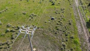
Infrastructure and Asset Inspection
For infrastructure and asset inspection, drones provide a clear picture of the condition of assets such as bridges, towers, and pipelines. This facilitates early detection of potential issues, allowing for preventative maintenance and extending the lifespan of these assets. Drone surveys negate the need for risky manual inspections and provide a level of detail that manual inspections might miss.
Case Study Integration
Each industry benefits uniquely from drone surveys, and National Drones has case studies to prove it. Our BHP Case Study showcases our work in providing comprehensive data for a large-scale environmental study, while our Our Western Water Case Study details how our drone services have been a game-changer for a client in the infrastructure sector.
Conclusion: A Versatile Tool for a Dynamic World
The versatility of drone surveys makes them invaluable in today’s dynamic and data-driven world. National Drones is at the forefront of exploring and expanding these applications, continuously pushing the boundaries of what is possible with UAV technology. We are not just a service provider; we are partners in our clients’ quests for efficiency, accuracy, and innovation.
In the following sections, we will explore the intricacies of data processing and analysis, and how the information gleaned from drone surveys is transformed into actionable insights.

Data Processing and Analysis in Drone Surveys
Once the drone has completed its aerial ballet, the dance of data begins. The raw inputs captured by our advanced drones—be it high-resolution imagery, thermal readings, or multispectral data—are but pieces of a larger puzzle. At National Drones, we employ a meticulous process to transform these raw inputs into a coherent and comprehensive narrative, utilising our proprietary software, SmartData, to turn data into decisions.
The Journey from Raw Data to Refined Analysis
The initial phase of data processing begins with the curation and calibration of raw inputs. Our technicians ensure that the data is accurate, aligning it with ground control points for geospatial accuracy and correcting any distortions caused by the camera lens or the flight pattern. This meticulous attention to detail is what sets the foundation for the high fidelity of our survey results.
Advanced Algorithms and Processing Techniques
The heart of our data processing lies within SmartData, where sophisticated algorithms come into play. Photogrammetry techniques are employed to stitch together a series of overlapping photographs, creating detailed orthomosaics and 3D models. For LiDAR data, point cloud processing is used to generate digital surface and terrain models, providing an accurate representation of the surveyed area.
SmartData: A Glimpse into Our Proprietary Software
SmartData is National Drones’ proprietary platform designed to handle the complexities of drone data processing. It is a robust suite that provides intuitive tools for analysing and visualizing data:
- 3D Modeling: Transforming 2D images into 3D models that offer immersive views and measurements.
- Volume Calculations: Utilizing the digital terrain models to calculate volumes with precision, essential for stockpile management and earthwork estimations.
- Thermal Analysis: Interpreting thermal images to identify heat signatures, which is critical in energy audits and infrastructure inspections.
- Vegetation Indexing: Analysing multispectral data to generate vegetation indices for agricultural health assessments.

SmartData is not just a data processing tool; it is a decision-making ally. It allows for the visualization of complex data sets in an accessible and interactive manner, ensuring that stakeholders can review and understand the insights without needing deep technical knowledge.
Ensuring Data Integrity and Quality Assurance
Data integrity is paramount. SmartData includes quality assurance protocols that validate the accuracy of the outputs. Our specialists scrutinize the processed data against known standards and control measures, ensuring that what we deliver is not just data, but verified information that you can trust.
Custom Reports and Deliverables
The final step in the data journey is the creation of custom reports and deliverables tailored to the specific needs of our clients. Whether it’s a detailed topographic map for a construction site or a comprehensive health report for a crop field, SmartData enables the generation of customized outputs that deliver insights in the most useful formats for our clients’ operations.
Conclusion: Technical Expertise Meets Innovative Software
With National Drones’ technical expertise and the innovative capabilities of SmartData, the raw data collected from drone surveys is transformed into strategic insights. This process is not just about technology; it’s about empowering clients with information that drives better business outcomes.
In the next section, we will delve into the regulatory landscape of drone operations and the importance of compliance in conducting high-quality drone surveys.
Cost-Benefit Analysis of Drone Surveys

As businesses increasingly look to maximize their investments, it becomes essential to scrutinize every tool and technology through the lens of cost-effectiveness. Drone surveys, with their swift execution and rich data capture, stand up to this scrutiny exceptionally well. At National Drones, we have conducted a thorough cost-benefit analysis to present a clear picture of the financial and operational advantages our drone survey services provide.
Quantifying the Economic Advantages
The economic benefits of drone surveys can be quantified by analysing both direct and indirect costs. Direct costs include the expenses saved by reducing the man-hours needed for traditional survey methods. Indirect costs, though often less apparent, include savings from mitigated risks, reduced downtime, and the prevention of costly errors.
For example, consider a large-scale infrastructure project. Traditional surveys might require a crew of surveyors over several weeks, incurring significant labour costs. Add to this the potential for project delays due to the extended time frame, and the costs continue to rise. Drone surveys can cut field time down to days and provide data more rapidly for analysis, significantly reducing both the direct and indirect costs.
Enhanced Data Quality and Its Financial Impact
The superior data quality provided by drone surveys translates into better planning and fewer mistakes. High-resolution imagery and precise topographic data allow for accurate calculations, reducing the likelihood of costly errors in the construction or planning phases. When changes in a project’s scope occur, the adaptability of drone technology allows for quick re-assessment at a fraction of the cost of traditional methods.
Long-Term Benefits: Beyond the Immediate Savings
The benefits of drone surveys extend beyond the immediate project at hand. The data collected serves as a valuable asset for future planning and maintenance, offering a long-term return on investment. Accurate models and maps become part of a project’s foundational data, which can be referenced for years to come, ensuring that the value of the initial survey continues to be realized over the lifecycle of the asset.
Real-World ROI: Case Studies from National Drones
Our real-world experience bears testimony to the cost-effectiveness of drone surveys. In one case study Mapping the Future: A Large Area Drone Survey covering 250 km², we demonstrated how a drone survey supported a large assessment project for a mining tenement. The drone survey led to a 30% reduction in total project costs and also accelerated the project timeline by 25% compared to traditional land survey techniques, enabling the client to proceed to the execution phase more swiftly than anticipated.
In another example – BHP Olympic Dam, drone surveys conducted for a mining client resulted in a 25% reduction in costs for a 200km2 aerial survey with increased data resolution.
Conclusion: A Smart Financial Decision
Investing in drone survey technology with National Drones is not just a strategic decision for project execution—it’s a sound financial decision. The cost savings, coupled with the long-term value of high-quality data, make drone surveys an indispensable tool for any project requiring accurate and efficient data collection.
As we look towards the future, the value proposition of drone surveying continues to grow, with National Drones leading the charge in providing cost-effective, technologically advanced survey solutions.
Success Stories
The narrative of innovation and efficiency we’ve woven through the capabilities of drone technology is best validated by the experiences of those who have witnessed its impact firsthand. At National Drones, we take pride in the trust and satisfaction echoed by our esteemed clientele. Their success stories not only speak to the effectiveness of our services but also serve as a testament to the collaborative partnerships we foster.
Social Proof: Our Clients’ Voices
Our journey with BHP underscored the transformative potential of drone surveys in the mining sector, optimizing their operations and enhancing safety protocols. Similarly, our collaboration with BAI Communications exemplifies how drone technology can be leveraged to maintain and upgrade essential communication infrastructures with minimal disruption and maximum efficiency.
Working with Aurecon and Sydney Trains, we showcased the integration of drone surveys in large-scale infrastructure projects, contributing to Sydney’s transport system’s robustness and reliability. Our work with QEM Limited highlighted how precise topographical data is crucial for the explorative stages of mining projects, leading to strategic decisions that underpin successful outcomes.
The NSW Department of Education relied on our drone services for the inspection and maintenance of educational facilities, ensuring the safety and integrity of the structures that house the future of our society. In each case, National Drones not only delivered on the promise of high-quality data but also provided the insights necessary to drive projects forward.

Conclusion: Your Trusted Partner in Drone Surveying
The confidence placed in us by such reputable organizations as BHP, BAI Communications, Aurecon/Sydney Trains, QEM, and the NSW Department of Education is not taken lightly. It fuels our drive to innovate and our commitment to excellence. These partnerships are the cornerstone of our mission—to deliver drone surveying services that not only meet but exceed expectations, ensuring that every project we undertake is a resounding success.
In the realm of drone surveying, National Drones is not just a provider but a proven ally, as evidenced by the trust of industry leaders and the success stories written together.

For More Information about anything RPAS related – use the form below to get in contact with us