Western Water
Reducing risks of incomplete and inaccurate registers
National Drones is helping Western Water to deliver efficiencies and improve the quality of their spatial asset register by locating and identifying ground assets such as hydrants, sewer pits and stormwater drains using aerial imaging, 3D mapping and geo-location.
Western Water is dedicated to finding innovative solutions using emerging and disruptive technologies to address challenges, new and old. Western Water is also working collaboratively with other utilities and local Government stakeholders to explore efficiency opportunities across organisations
Other case studies
THE CHALLENGES
A common problem for water authorities is maintaining the completeness and accuracy of their asset register and spatial database. In many cases asset locations may be incorrectly located, or missing altogether, which impacts ability to plan and manage assets adequately, and increases the risks of unplanned events.
Assets such as sewer pits and stormwater drains are often located in residential backyards. This makes accessing and inspecting the asset costly and time consuming. In many cases it’s not possible to know if a householder has covered or built over an asset without a physical inspection. In addition, legacy registers typically lack important information about the location of adjacent non-water assets (e.g. energy, telco), which are critical to plan and reduce risks of water asset maintenance jobs.
THE SOLUTION
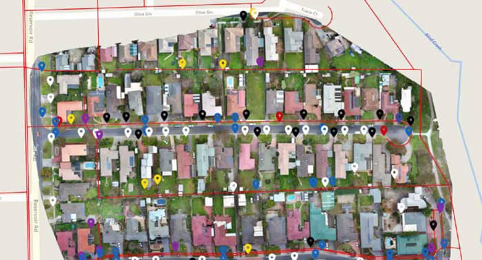
- Aerial photogrammetry survey – Unmanned Aerial Vehicle (UAV) high resolution image / mapping asset data capture. A UAV is a quick and costeffective method for capturing high quality survey data. Combined with Ground Control Points (GCP) positional accuracy of less than 10cm can be achieved.
- Desktop asset identification and location – Captured aerial imagery is post processed to create a high resolution georeferenced map of the survey site. Ground assets are identified and categorised using a web based platform.
- Comparison to GIS database – Once ground assets have been identified, Western Water GIS data is imported and overlaid on the aerial image data. Missing and/or incorrectly located assets can be quickly identified for database location adjustment and/or field investigation.
- Online inspection and reporting tools – Results can be quickly shared with field staff via the online platform or by report generation pinpointing the exact assets and locations where further investigation is required.
THE RESULTS
Initial trails with Western Water have provided valuable data insights for the trial locations assessed to date. Over an initial area of 8.5ha (approximately 60 residential blocks) circa 120 ground assets were identified (both water and non-water). 31 ground assets not previously included in the GIS database were identified including storm water drains and pits. A number of fire plugs / hydrant locations were identified that were incorrectly located, or not present on the GIS datasets.
Whilst further work to cleanse the GIS datasets is underway, initial results identified a number of locations requiring field investigation to locate assets, or where asset location needs to be updated on the GIS database. In addition, 52 non-water assets were mapped including underground electrical pits and telco pits. Western Water have engaged National Drones to conduct lager scale trials.
“We are investigating new technology to ensure tasks reduce the OHS risk to our staff, minimise impact to our customers and deliver efficiencies within our business. We are working with National Drones to investigate any opportunities to deliver this.”
Dean BarnettManager Field Services & Network OPERATIONS – WESTERN WATER
THE BENEFITS FOR WESTERN WATER

Reduced field operations time required for asset inspections from days to hours

Optimised allocation of field operation resources for proactive issue investigation and resolution, instead of time-consuming data collection and reactive work

Improved asset register - spatial database quality, both in terms of completeness, with newly found and verified assets, as well as accuracy, through high resolution imagery and geo-location precision.

Enhanced online data availability for stakeholders, comparing GIS layers with aerial imagery
Download this Case Study
You can download this case study by filling out the form below or go back and view more case studies.