RBMO - Meteorology
Weather Risk for Drone Operations
A practical guide to reading weather as operational risk: wind, visibility, turbulence, temperature, rain, humidity and thunderstorms.
Lesson record
- Status
- Current source aligned
- Reviewed
- 2026-05-18
- Source pages
- RePL Study Guide pp. 107-140; Part 101 MOS C10 p. 96.
- Reviewer
- National Drones publication review
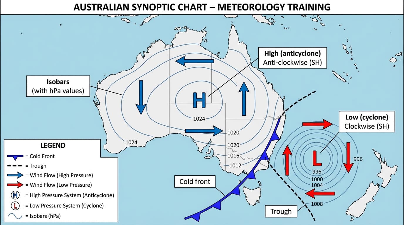
Image provenance: Existing National Drones meteorology diagram, reviewed for this starter slice.
Weather is a flight decision
For RPA operations, weather is not background information. It affects control margin, battery endurance, visibility, navigation confidence, payload performance and crew workload.
A good weather decision starts before the aircraft is powered on. The remote pilot asks: can I keep the aircraft under control, keep it in sight, keep separation from people and obstacles, and still have enough reserve to recover safely if the conditions change?
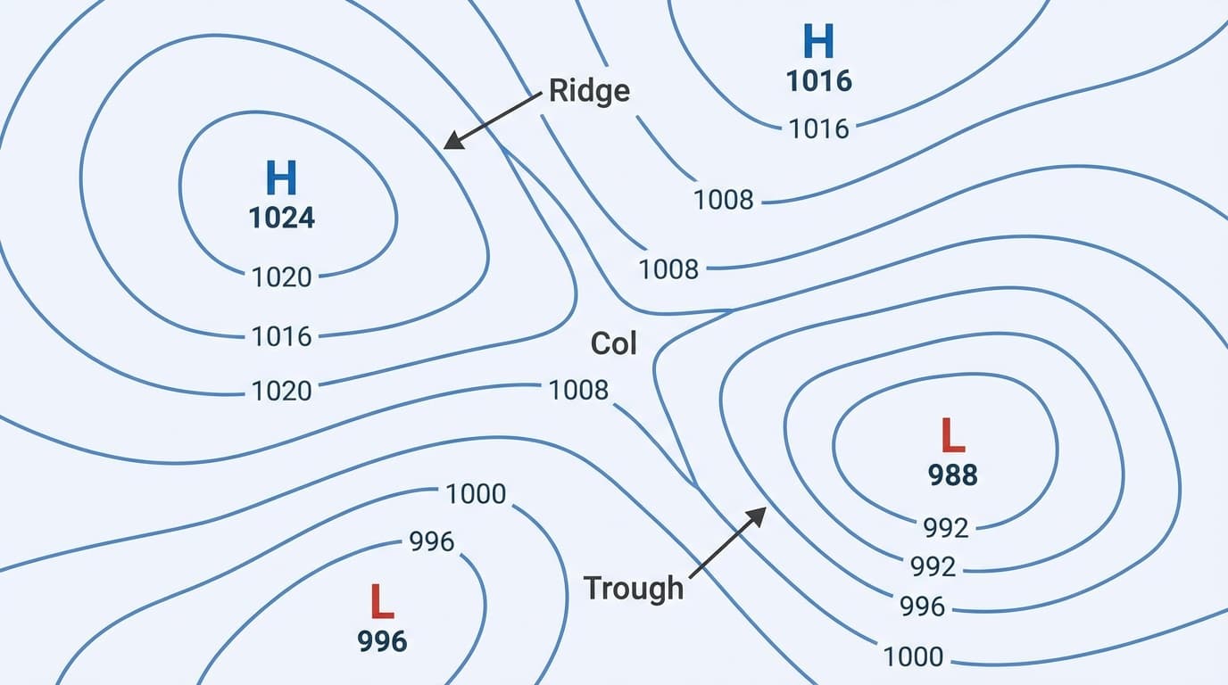
Start with the big weather picture
Weather maps and forecasts help you understand why the local conditions are doing what they are doing. Pressure systems, troughs, ridges and fronts can all point to wind, cloud, rain, turbulence or storms before they arrive at the job site.
For RePL study, you do not need to become a meteorologist. You do need to recognise the common symbols and connect them to operational risk: closely spaced isobars usually mean stronger wind, lows and troughs can bring unsettled weather, and fronts often bring changes in wind, cloud and rain.
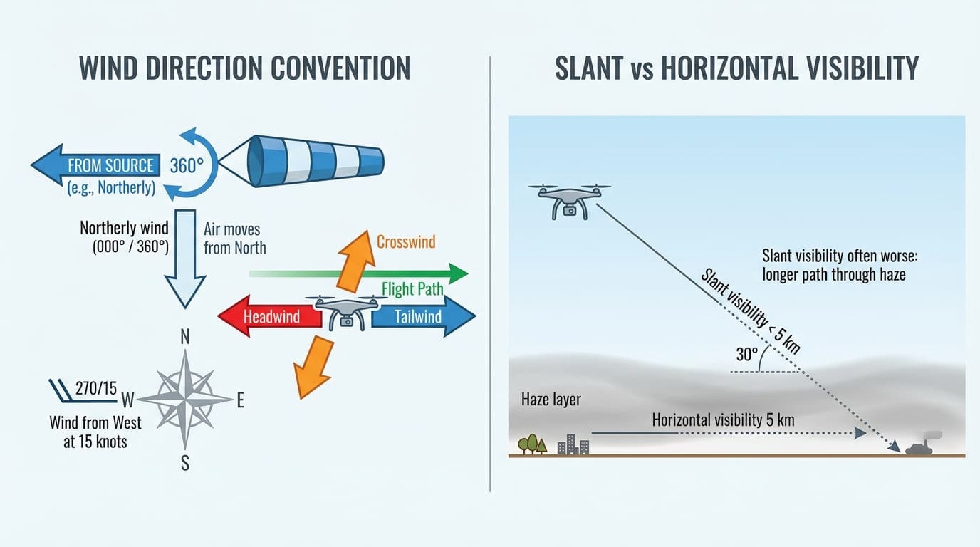
Wind deserves more than one number
A forecast wind can be useful, but the operating site may tell a different story. Measure or observe wind at the launch point, near obstacles and along the likely flight path. The mean wind is only the starting point.
Strong wind can reduce endurance, increase drift and make precision work harder. Gusts matter because the aircraft is constantly being asked to correct. Windshear and wind gradient matter because wind can change sharply with height or position.

- Headwind can slow the return and increase battery use.
- Tailwind can make the aircraft cover ground faster than expected.
- Crosswind creates drift and may reduce the precision of inspection or mapping runs.
- Mechanical turbulence can form downwind of buildings, trees, ridgelines and other obstructions.
Visibility and cloud protect VLOS
Remote pilots rely on sight. Poor visibility, low cloud, fog, mist, dust, haze, smoke and rain can all make it harder to maintain visual line of sight, judge distance, see other aircraft, and keep the aircraft clear of obstacles.
The trap is that visibility may look acceptable at ground level but be worse along a slant path through haze or mist. If the observer or remote pilot cannot reliably see and orient the aircraft, the weather is already changing the operation.
- Low cloud can hide terrain, towers, masts, wires and crewed aircraft.
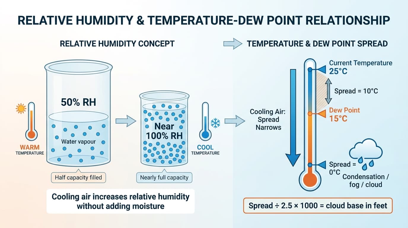
- Fog and mist can form quickly when temperature and dew point are close.
- Dust, haze and smoke can reduce contrast and make a small RPA difficult to orient.
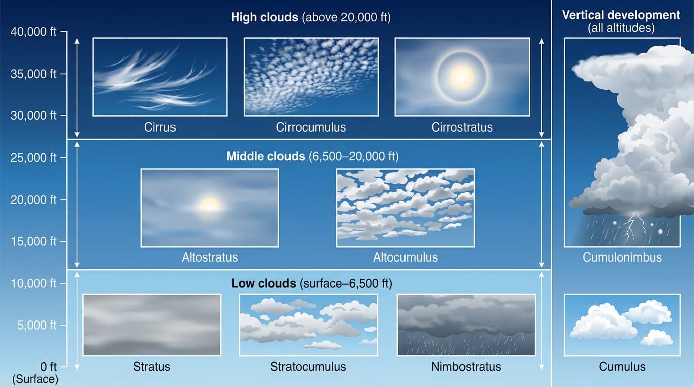
Cloud type tells a story
Clouds are visible clues about the air. Layered cloud often points to widespread stable conditions and reduced ceiling. Puffy cumulus points to rising air. Cumulonimbus is a major warning sign because it is linked to strong updrafts, downdrafts, turbulence, lightning, hail and heavy rain.
The exact cloud name is less important than the flying implication. Ask what the cloud says about visibility, turbulence, precipitation and change over the next part of the operation.
Thunderstorms and convection are no-go signals
Convection is rising air. Gentle convection can produce thermals and bumps. Strong convection can build towering cloud and thunderstorms. For RPA operations, thunderstorms should be treated as a stop-work weather condition, not as something to work around at close range.
The mature stage of a thunderstorm can include heavy rain, hail, lightning, severe turbulence, strong downdrafts and gust fronts. Those hazards can arrive before the rain reaches the launch point.
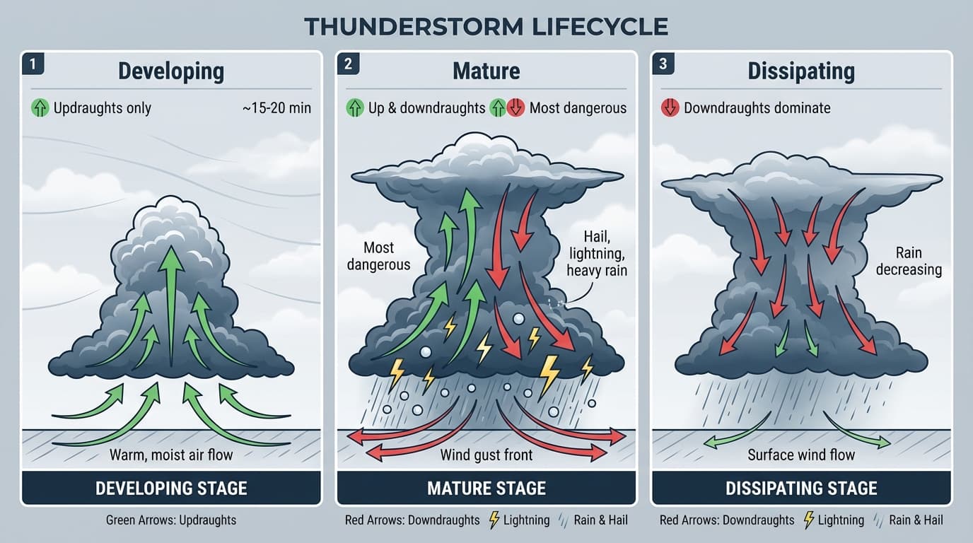
- Watch for towering cumulus, virga, lightning, sudden wind shifts and rapidly darkening cloud.
- Dust devils and strong thermals indicate unstable rising air near the surface.
- If the weather is building quickly, land early and reassess.
Rain, humidity and temperature affect more than comfort
Rain can reduce visibility, wet aircraft surfaces, affect payloads and sensors, and introduce water risk to electrical systems. Humidity matters because it helps explain fog, cloud and condensation. A small temperature-dew point spread means the air is close to saturation.
Extreme heat and cold can also reduce performance margin. Heat can stress batteries and electronics. Cold can reduce battery output and make voltage sag more noticeable under load. Both can change endurance from what the pilot expected.
- Do not assume battery endurance from a calm, mild day will hold in heat, cold or strong wind.
- Moisture can affect optics, payload data quality and electrical reliability.
- Precipitation static and charged dust or precipitation are weather warning signs around convective or unsettled conditions.
Use forecasts, reports and site observations together
Aeronautical forecasts and reports help with aviation-specific planning. Public forecasts help with broader local context. Field observations tell you what is happening at the launch site and along the planned flight path.
The professional habit is to compare the sources. If the forecast says benign conditions but the site shows gusts, dust, low cloud or building convection, the site gets a vote.
- Check current and forecast wind, gusts, cloud, visibility, rain and temperature.
- Look for signs of thermals, dust devils, turbulence, wind gradient and windshear.
- Review relevant aeronautical weather products for the operating area when available.
- Keep checking conditions during the job, not only before take-off.
Make the go, modify or no-go call
Weather decisions are not only go or no-go. Often the safest answer is to modify the task: reduce distance, change the flight line, increase crew separation, delay until visibility improves, fly a smaller area, or stop before the weather trend reaches the site.
If the operation depends on fine margins, delay or redesign the task. A good remote pilot is not rewarded for launching into a situation that was already doubtful on the ground.
- Go when conditions are inside aircraft, crew, site and approval limits with healthy reserve.
- Modify when the task can be made simpler and safer without pretending the risk has disappeared.
- No-go when control, visibility, separation, endurance or recovery margin is doubtful.
Practice Questions
Why can a public forecast be insufficient on its own for a drone job?
- It may not describe local gusts, turbulence or obstacles at the operating site.
- It always gives exact wind at the launch point.
- It replaces all field observations.
- It only applies to crewed aircraft.
Answer: It may not describe local gusts, turbulence or obstacles at the operating site.
Remote pilots need forecasts and local observations because small RPA are sensitive to site-level conditions.
A forecast wind is within the aircraft limit, but the launch site is downwind of buildings and trees with rapid gusts. What is the main concern?
- Mechanical turbulence and gust spread may make the site riskier than the mean forecast wind suggests.
- Buildings always remove wind risk.
- Only wind above cloud level matters to RPA.
- A forecast wind automatically overrides local observations.
Answer: Mechanical turbulence and gust spread may make the site riskier than the mean forecast wind suggests.
Local obstacles can create turbulent, changing airflow. The pilot should consider the actual site conditions, not just the mean forecast wind.
Why is a mature thunderstorm unsuitable for RPA operations nearby?
- It can produce strong updrafts, downdrafts, gust fronts, lightning, hail and heavy rain.
- It always produces perfectly smooth air.
- It improves VLOS by clearing all cloud.
- It only affects aircraft above 10,000 ft.
Answer: It can produce strong updrafts, downdrafts, gust fronts, lightning, hail and heavy rain.
Thunderstorm hazards can affect low-level RPA operations and can arrive before rain reaches the launch point.
What does a small temperature-dew point spread warn a remote pilot about?
- The air is close to saturation, so fog, cloud or condensation may be more likely.
- The wind direction has changed by 180 degrees.
- Battery voltage is guaranteed to increase.
- The aircraft no longer needs visual line of sight.
Answer: The air is close to saturation, so fog, cloud or condensation may be more likely.
When air temperature approaches the dew point, the air may become saturated and visible moisture can form.
Next step after study
Complete your Remote Pilot Licence training
The free study guide is a strong theory foundation. To actually be issued with a RePL, students still complete approved training, practical flying and assessment with a certified provider.