LiDAR Drone Surveys
12 August 2023
LiDAR Drone Surveys
LiDAR (Light Detection and Ranging) is a remote sensing technology that uses laser pulses to measure distances and create highly accurate three-dimensional representations of the earth's surface and the features on it. When mounted on a drone, LiDAR becomes a fast, efficient, and cost-effective tool for capturing detailed survey data across a wide range of applications.
How LiDAR Works
A LiDAR sensor emits thousands of laser pulses per second toward the ground. Each pulse reflects off surfaces it encounters, and the sensor records the time it takes for the pulse to return. By combining this distance measurement with precise GPS positioning and inertial measurement data, the system calculates the exact three-dimensional position of each point where the laser reflected.
The result is a dense point cloud comprising millions of 3D coordinates that accurately represent the shape and position of surfaces, structures, and objects within the survey area.
LiDAR vs Photogrammetry
Both LiDAR and photogrammetry (camera-based mapping) produce 3D point clouds and surface models, but they have different strengths.
When to Use LiDAR
- Dense vegetation -- LiDAR pulses can penetrate tree canopy and understory to map the bare earth beneath. This is something photogrammetry cannot do.
- Low-light conditions -- LiDAR is an active sensor and does not rely on ambient light, making it effective in overcast or shaded conditions.
- Bare earth extraction -- LiDAR data can be classified to separate ground returns from vegetation, buildings, and other features, producing accurate digital terrain models.
- High vertical accuracy -- LiDAR typically achieves better vertical accuracy than photogrammetry, particularly in challenging terrain.
When to Use Photogrammetry
- Visual context -- Photogrammetry produces high-resolution orthophotos and textured 3D models that provide visual context LiDAR cannot.
- Cost -- Photogrammetry equipment is generally less expensive than LiDAR sensors.
- Open terrain -- In areas without dense vegetation, photogrammetry can achieve comparable accuracy at lower cost.
In many projects, the best approach is to combine both technologies, using LiDAR for accurate terrain data and photogrammetry for visual context.
Accuracy
Drone-mounted LiDAR systems can achieve:
- Absolute accuracy: 2 to 5 centimetres with proper ground control
- Point density: 100 to 500+ points per square metre
- Multiple returns: Capturing up to 5 or more returns per laser pulse, allowing separation of canopy, mid-story vegetation, and ground
Applications
Land Surveying
LiDAR is used to produce topographic surveys, contour maps, and digital terrain models for engineering design, land development, and planning applications. The ability to survey through vegetation without clearing reduces project timelines and environmental impact.
Forestry
In forestry applications, LiDAR is used for:
- Canopy height modelling
- Timber volume estimation
- Forest inventory and classification
- Fire fuel load assessment
- Access road planning
Mining
Mining companies use LiDAR for:
- Pit and dump surveys with high accuracy
- Volumetric calculations of stockpiles
- Monitoring subsidence and ground movement
- Planning and design of earthworks
- Rehabilitation monitoring
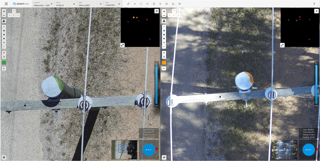
Infrastructure and Utilities
LiDAR is widely used for infrastructure projects including:
- Road and rail corridor surveys
- Powerline clearance assessment
- Pipeline route planning
- Flood modelling and drainage analysis
- Bridge and retaining wall surveys
Archaeology and Cultural Heritage
LiDAR's ability to see through vegetation has made it a valuable tool for archaeological surveys, revealing features such as ancient structures, earthworks, and landscape modifications that are hidden beneath forest canopy.
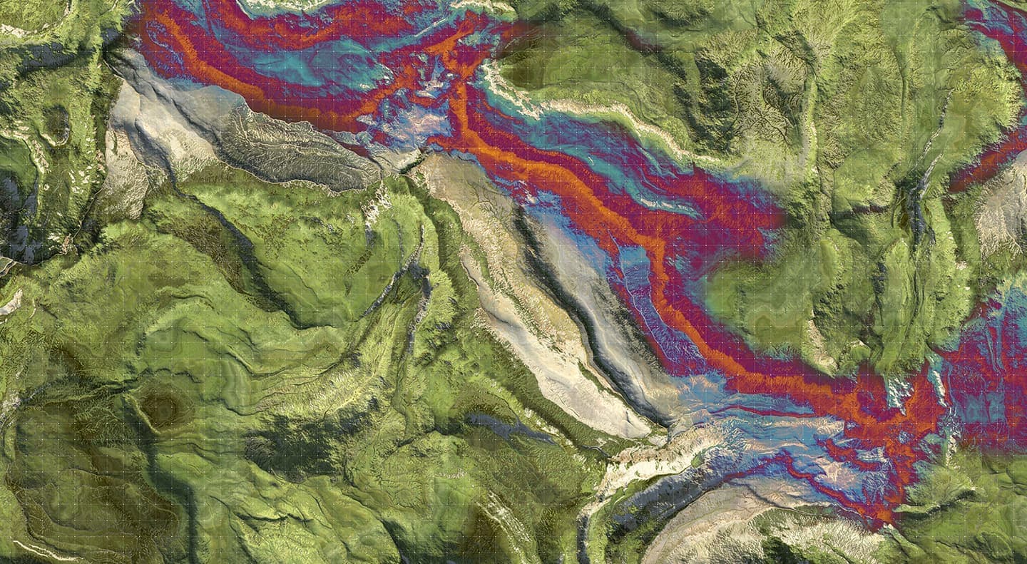
Coastal and Environmental Monitoring
LiDAR supports environmental management through:
- Coastal erosion monitoring
- Wetland and riparian zone mapping
- Habitat classification
- Volumetric change detection
Our LiDAR Capabilities
National Drones operates drone-mounted LiDAR systems capable of surveying large areas with centimetre-level accuracy. Our systems capture dense point clouds with multiple returns, allowing us to produce accurate bare-earth models even in heavily vegetated areas.
Our LiDAR survey deliverables include:
- Classified 3D point clouds (ground, vegetation, structures)
- Digital terrain models (DTM)
- Digital surface models (DSM)
- Contour maps at specified intervals
- Cross-sections and profiles
- Volumetric calculations
- Integration with existing survey data and coordinate systems
Getting Started
If your project requires accurate terrain data, particularly in vegetated or difficult-to-access areas, LiDAR drone surveys may be the most effective solution. Contact National Drones to discuss your requirements and receive a quote.