How AI and Drones Are Transforming Asset Management Across Australia
20 March 2026
How AI and Drones Are Transforming Asset Management Across Australia
If you manage infrastructure in Australia, you already know the challenge. The assets are spread across vast distances, often in harsh environments, and the cost of getting people out to inspect them is enormous. A single helicopter sortie to check a remote transmission line can cost more than most small businesses spend on marketing in a month. And that's before you factor in the safety risks.
Over the past few years, drones have gone from novelty gadgets to essential tools in the asset management toolkit. But the real shift isn't just about replacing helicopters with quadcopters. It's about what happens when you combine drone-captured data with artificial intelligence -- and the results are genuinely changing how Australian businesses think about maintaining their assets.
What Do We Mean by Asset Management?
Before diving into the technology, it's worth stepping back and thinking about what asset management actually covers. The term gets thrown around a lot, but in practice it encompasses an enormous range of industries and infrastructure types:
- Energy networks -- Transmission towers, distribution poles, substations, solar farms, wind turbines, and the thousands of kilometres of cabling connecting them all
- Mining operations -- Open pit mines, underground portals, haul roads, tailings dams, processing plants, stockpiles, and rehabilitation areas
- Forestry and vegetation -- Plantation timber, native forest health, vegetation encroachment on infrastructure corridors, and post-fire regeneration monitoring
- Transport infrastructure -- Road surfaces, bridges, rail corridors, ports, and airport runways
- Water infrastructure -- Dams, levees, pipelines, treatment plants, and stormwater systems
- Telecommunications -- Towers, antenna arrays, fibre routes, and associated access infrastructure
- Built environment -- Rooftops, facades, building envelopes, and commercial property portfolios
What all of these have in common is that they're physical assets that degrade over time, need regular inspection, and cost serious money to repair or replace. The traditional approach has been to send people out on a schedule -- quarterly inspections, annual surveys, five-yearly condition assessments -- regardless of whether anything has actually changed.
That approach worked when there weren't better alternatives. Now there are.
The Drone Advantage: More Than Just a Camera in the Sky
The first wave of commercial drone adoption in asset management was straightforward: put a camera on a drone, fly it over the asset, and take photos. It was cheaper than a helicopter and safer than sending someone up a ladder or into a confined space. That alone justified the investment for many organisations.
But the real value of drones isn't just that they can fly. It's the data they collect and, increasingly, what AI can do with that data.
Multi-Sensor Payloads
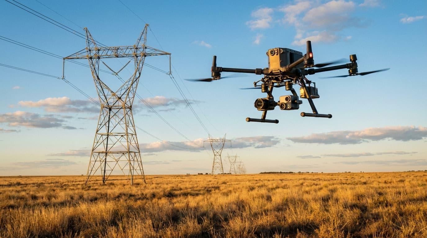
Modern inspection drones carry far more than a standard camera. A typical asset inspection platform might include:
- High-resolution RGB cameras -- 45+ megapixel sensors that can resolve millimetre-scale defects from safe standoff distances
- Thermal cameras -- Radiometric sensors that measure surface temperatures with precision, detecting hotspots in electrical connections, moisture ingress in building envelopes, or heat loss in industrial processes
- LiDAR sensors -- Laser scanners that produce dense 3D point clouds, accurate to within a few centimetres, for volumetric measurement and spatial analysis
- Multispectral cameras -- Sensors that capture light beyond what the human eye can see, revealing vegetation stress, material composition changes, or contamination
A single drone flight can capture all of this data simultaneously, creating a rich digital record of the asset's condition at a specific point in time.
Repeat Coverage and Change Detection
One of the most powerful aspects of drone-based asset management is the ability to survey the same asset repeatedly and compare results over time. This is where AI really starts to earn its keep.
When you fly the same powerline corridor every six months and capture identical datasets each time, AI algorithms can automatically identify what has changed between surveys. A new crack in a crossarm. A tree that's grown into a clearance zone. A subtle shift in a retaining wall. These changes might be invisible to a human reviewing thousands of individual images, but machine learning models trained on historical data can flag them with remarkable accuracy.
This shift from periodic human inspection to continuous AI-monitored surveillance is the fundamental transformation happening in asset management right now.
Industry by Industry: Where AI-Powered Drones Are Making the Biggest Impact
Energy and Utilities
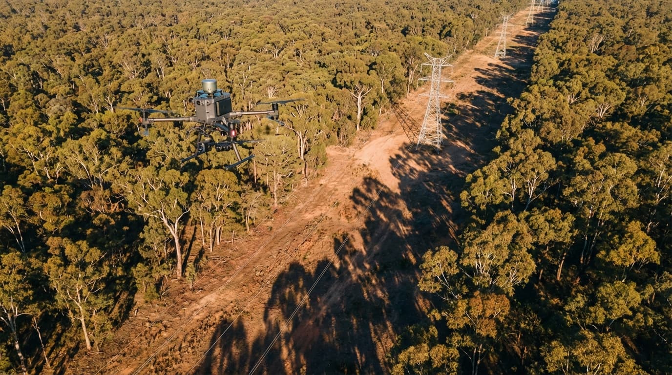
Australia's electricity network is one of the longest in the world, spanning approximately 900,000 kilometres of transmission and distribution lines. Keeping this network reliable and safe is a massive undertaking, and vegetation management alone costs the industry hundreds of millions of dollars annually.
Drone-captured LiDAR data, processed by AI, can automatically classify vegetation species, measure proximity to conductors, predict growth rates, and prioritise clearing schedules. Instead of clearing everything on a fixed cycle, utilities can target their vegetation management spend where the risk is highest. The savings are substantial -- early adopters have reported reductions in vegetation management costs of 20 to 30 percent while actually improving compliance with clearance standards.
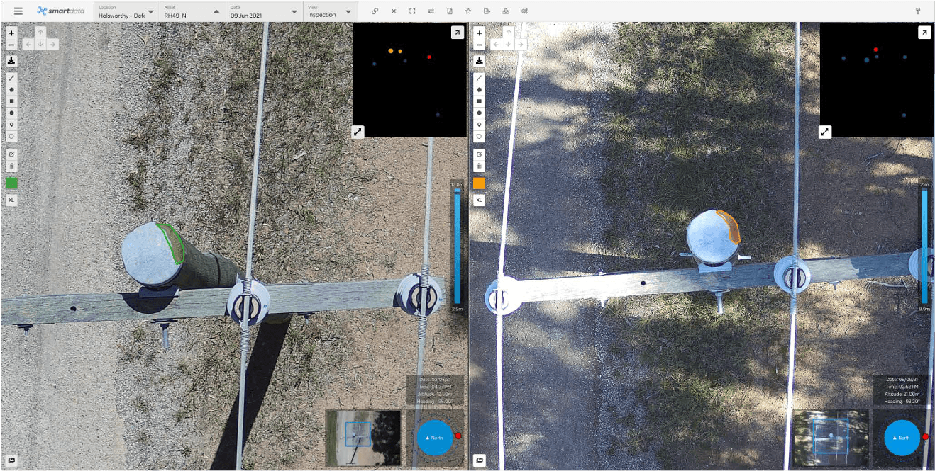
Thermal imaging from drones also picks up failing connections and overloaded components that ground-based patrols would never see. A hot joint on a transmission tower 40 metres above the ground is invisible from the ground but obvious from a thermal camera mounted on a drone flying at conductor height.
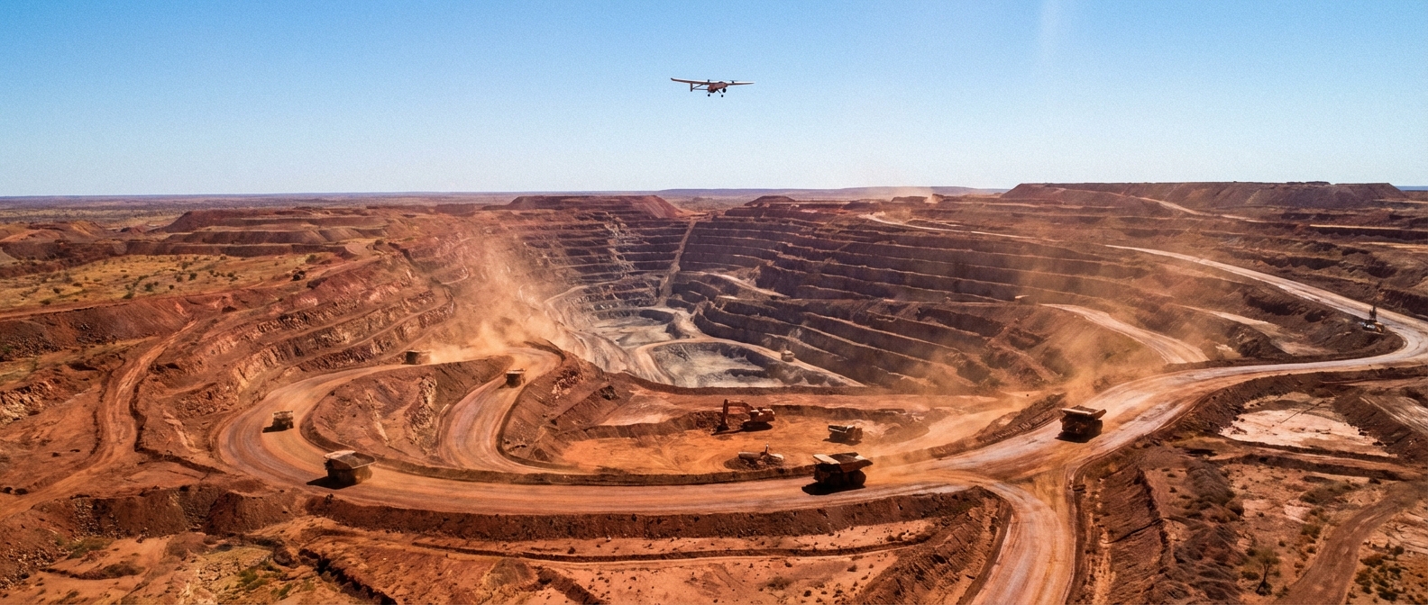
Mining
The mining industry was one of the first sectors to adopt drones at scale in Australia, and the use cases keep expanding. Stockpile volumetrics -- measuring how much material is sitting in a stockpile -- was the entry point for most operations. Drone surveys replaced manual GPS surveys, cutting measurement time from days to hours while improving accuracy.
But AI has pushed mining drone applications well beyond stockpile measurement:
- Blast fragmentation analysis -- AI models analyse post-blast imagery to characterise rock fragmentation, providing feedback that optimises future blast designs and reduces downstream processing costs
- Pit wall monitoring -- Machine learning algorithms detect subtle movements in pit walls between surveys, providing early warning of potential geotechnical failures
- Haul road condition assessment -- AI processes drone imagery to identify potholes, corrugation, and drainage issues on haul roads, enabling proactive maintenance that reduces tyre wear and improves cycle times
- Rehabilitation monitoring -- Multispectral drone data feeds AI models that track revegetation progress, soil stability, and erosion on rehabilitated mine areas, providing objective evidence for regulatory reporting
Forestry and Vegetation Management
Australia's forestry sector manages millions of hectares of plantation and native forest. Traditional forest inventory methods -- sending crews into the bush with measuring tapes and clinometers -- are slow, expensive, and provide only sample-based estimates.
Drones equipped with LiDAR can survey an entire plantation compartment in a fraction of the time, capturing individual tree heights, canopy density, and stand structure. AI processes this data to estimate timber volumes, identify pest or disease outbreaks from subtle canopy discolouration, and model growth projections.
For vegetation management around infrastructure corridors, the combination of drones and AI is proving transformative. Instead of ground crews walking every kilometre of a transmission line easement, drones capture corridor-wide data that AI analyses to identify encroachment risks, classify species, and generate prioritised work orders for clearing crews.
Transport and Civil Infrastructure
Bridges, roads, and rail corridors are ageing across Australia, and the cost of condition assessment is significant. Drone inspections of bridges can capture detailed imagery of every structural element -- abutments, piers, bearings, deck soffits, expansion joints -- without the need for under-bridge inspection units or traffic management plans.
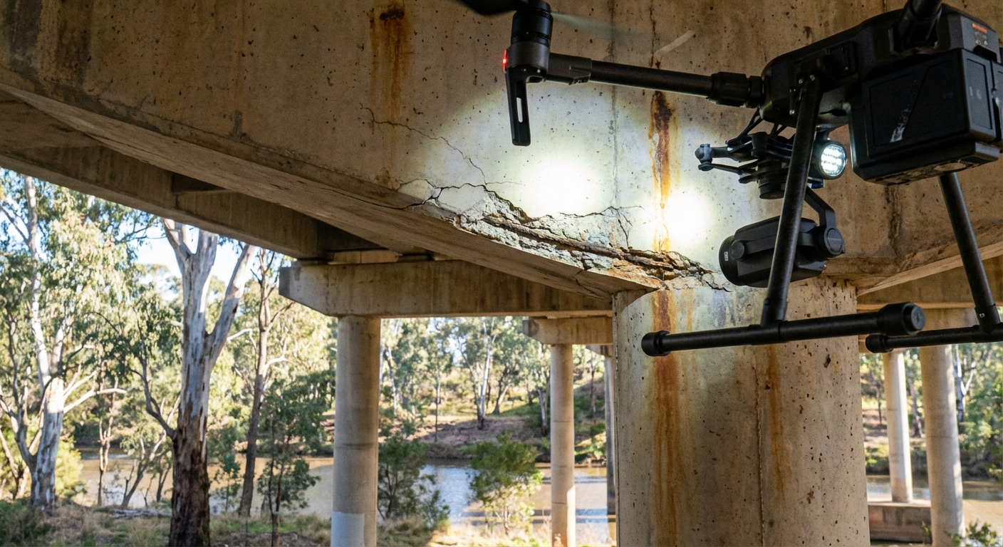
AI models trained on thousands of bridge defect images can automatically classify and severity-rate cracks, spalling, corrosion, and delamination. This doesn't replace the engineer's judgement, but it dramatically accelerates the screening process. An AI model can review 10,000 images overnight and present the engineer with a shortlist of components that need attention, rather than requiring them to review every image manually.
Road surface condition assessment follows a similar pattern. Drones capture high-resolution imagery of road surfaces, and AI algorithms detect and classify defects -- cracking, rutting, potholing, edge break -- across the entire network. The output feeds directly into pavement management systems, enabling data-driven prioritisation of maintenance and rehabilitation spend.
The Data Platform: Where It All Comes Together
The drone is just the collection device. The real value sits in the data platform that stores, processes, and analyses the information over time. A mature AI-powered asset management platform provides:
- Automated defect detection -- AI models identify and classify defects in captured imagery without human intervention
- Condition trending -- Tracking how asset condition changes over successive surveys to predict when intervention will be needed
- Risk scoring -- Combining defect data with consequence modelling to prioritise maintenance based on risk rather than schedule
- Digital twins -- 3D models of assets that can be interrogated remotely, reducing the need for site visits
- Regulatory reporting -- Automated generation of compliance reports from survey data
This is the direction the industry is heading. Not just flying drones and taking photos, but building living digital records of asset condition that are continuously updated and intelligently analysed.
Practical Considerations
Regulation
All commercial drone operations in Australia must comply with CASA regulations. Operators need a Remote Pilot Licence (RePL) and their organisation needs a Remotely Piloted Aircraft Operator's Certificate (ReOC). Operations near airports, in controlled airspace, or beyond visual line of sight require additional approvals.
For asset owners considering drone-based inspection programs, it's important to work with operators who understand both the regulatory requirements and the specific challenges of the asset class they're inspecting.
Data Management
A single drone survey can generate tens of gigabytes of data. Scale that across an entire asset portfolio and multiple survey cycles, and data management becomes a significant consideration. Cloud-based platforms with appropriate security controls are essential, and organisations need clear data governance policies covering retention, access, and use.
Integration with Existing Systems
The greatest value comes when drone-captured data integrates with existing asset management systems, GIS platforms, and enterprise resource planning tools. AI-generated defect reports that feed directly into maintenance work order systems close the loop between detection and action, reducing the time between identifying a problem and fixing it.
Where Things Are Heading
The pace of development in both drone hardware and AI software shows no sign of slowing. Several trends are worth watching:
- Beyond Visual Line of Sight (BVLOS) operations -- Regulatory frameworks for BVLOS are maturing, which will enable drones to survey long linear assets like pipelines, powerlines, and rail corridors far more efficiently
- Autonomous operations -- Dock-based drones that launch, fly, capture data, and return without human intervention are already in use on some mine sites and are expanding into other sectors
- Edge computing -- AI processing on the drone itself, enabling real-time defect detection during flight rather than post-processing after landing
- Sensor fusion -- Combining data from multiple sensor types in real-time to provide richer situational awareness during inspections
The organisations that will benefit most from these developments are the ones investing now in the data foundations -- building historical datasets, training AI models on their specific asset types, and integrating drone data into their operational workflows.
Getting Started
If you're managing physical assets and haven't yet explored drone-based inspection, the barrier to entry is lower than you might think. A well-planned pilot program targeting a specific asset class can demonstrate value quickly and build the business case for broader adoption.
The key is to start with a clear question: what do you need to know about your assets that you can't easily find out today? Whether it's the condition of a remote bridge, the volume of a stockpile, or the proximity of vegetation to a powerline, there's likely a drone-and-AI solution that can answer that question faster, cheaper, and safer than traditional methods.
At National Drones, we work with asset owners across Australia to design and deliver drone inspection programs that generate actionable intelligence. If you're interested in exploring how drone technology could improve your asset management outcomes, get in touch.