Gippsland Water
Assets Condition Assessment
National Drones partnered with Gippsland Water to reduce maintenance inspection durations and improve understanding of major asset conditions using aerial image surveys, thermal imaging, and NDVI analysis.
Gippsland Water provides water, wastewater, and waste recovery services across Central Gippsland, Victoria, serving over 65,000 customers across 5,000+ square kilometres.
The Challenges
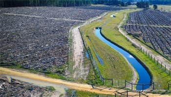
Gippsland Water manages an 85.6-kilometre Regional Outfall Sewer (ROS) comprising 40.6km open channel and 45km underground pipeline. Routine inspections on foot or by vehicle occurred monthly, consuming significant resources. A 2.5km trial site near East Sale Air Force Base required special flight permissions due to restricted military airspace.
The Solution
A three-part approach was implemented:
- Aerial photogrammetry survey — High-resolution UAV image capture of the ROS trial site
- Desktop assessment — Post-processed imagery creation with georeferenced mapping to identify ground assets, condition issues (bank erosion, blockages), and potential groundwater leakage areas
- Online inspection and reporting tools — Results shared with field staff via online platforms or generated reports with precise asset locations
The Results
- Survey completed over 2.5km covering approximately 23 hectares
- Completed in 2.5 hours by two operators (pilot and spotter)
- 700 high-resolution images captured
- Two maintenance issues identified
- Unique aerial perspective revealed features not easily visible at ground level
The Benefits
- Reduced field inspection time from days to hours via desktop assessment
- Optimised field resource allocation for proactive investigation
- Early detection and resolution of maintenance issues
- Enhanced work planning through change monitoring
- Improved asset register quality and accuracy
- Enhanced stakeholder data availability
Additional capabilities include Ground Control Points (GCP) for elevation, slope, and contour mapping, plus thermal imaging and NDVI monitoring trials.